ActiveG and the City of Corpus Christi

In 2014, the City of Corpus Christi, Texas chose ActiveG MapEngine as its spatial integration for Maximo, replacing a legacy spatial integration. “The city really needed a modern and extensible spatial capability for Maximo,” says Jeff Meyer—Senior Functional Analyst. “ActiveG MapEngine fit that need exactly. It allows us to really leverage our GIS and Maximo systems in ways we never even considered.”
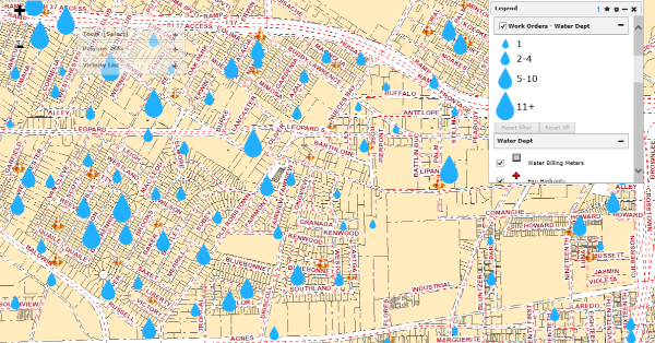
The city now uses MapEngine in Maximo for creating service requests and work orders, for tracking customer calls, and for monitoring the work in several city departments, including Water, Waste Water, Gas, Solid Waste, and Streets.
“ActiveG…exceeded our expectations…”
The City’s customer call center takes several hundred calls a day from residents. Many of these calls result in Service Requests or Work Orders in Maximo. Customer Service Representatives (CSRs) utilize MapEngine to locate service premises or water meters, and these records are assigned to work orders in Maximo.
This gives the Maintenance Department instant visibility to the location of potential work orders and easy work order progress tracking. It also gives the CSRs instant visibility into the location of incidents reported from similar incoming calls, allowing them to give customers better information about local incidents.
Visual feedback for Meter Reading/Condition Monitoring
The implementation of MapEngine allowed the City to take advantage of a map in Maximo in many new and different ways. For instance, technicians can enter meter information or condition readings via the map. Users simply click on a map feature that corresponds to the asset in question, then enter the condition or meter information. This makes asset selection more accurate (improving data quality) and also provides the supervisors visual feedback for assets that are out of tolerance, ensuring the right assets get the right amount of attention.
Data Management for optimal integration between Maximo and GIS
As part of its MapEngine project, the City of Corpus Christi implemented ActiveG’s proven data synchronization process and tools for GIS and Maximo. The city was able to connect more than 20 GIS feature classes to Maximo via this process, which regularly keeps Maximo updated with fresh information coming from the GIS source data. This process is managed and maintained by the city’s IT department, and as needed, they have added additional feature classes which are now created as Maximo records. Also, this nightly process notifies interested personnel of recent changes.
Customer Satisfaction with an Eye on the Future
Overall, the successful MapEngine implementation has met the needs of the various city departments, with the city considering additional spatial support for Facilities Management and Utility Asset Downtime Management. “The MapEngine implementation for Corpus Christi was fast and effective,” says Bill Mahaffey, Assistant Director—Maintenance of Lines. “The ActiveG staff was knowledgeable about Maximo and GIS, and they exceeded our expectations by identifying and providing solutions for various user requirements, from the technicians in the field to office staff.”
Contact ActiveG today for more information and to see an online demo.
At A Glance
Client:
Industry
- Water, Waste Water, Gas, Streets
Highlights
- Replaced aging spatial integration to Maximo
- Data management process and tools, integrating GIS and Maximo data.
- Delivered spatial capabilities for Work Order Tracking, Service Requests, and Locations applications
- Configurable, flexible Work Order visualization and clustering
- Maximo-centric maps now accessible to non-Maximo Users
- Rapid implementation