ActiveG Nash Workflows
Workflow Engine for ArcGIS, Maximo, and more.
Sign up for 60-day Nash trial today and get started!

Let the good ideas flow
Nash Workflows is a powerful no-code automation engine that seamlessly integrates with Esri ArcGIS to provide real-time data processing and automation. Nash Workflows enables organizations to build robust business processes that tie various systems together via REST APIs, including email (SMTP), IBM Maximo, and ServiceNow.
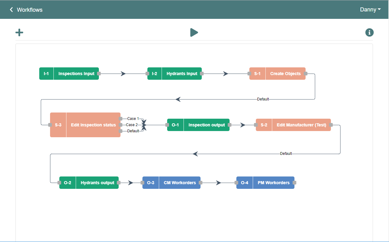
One of the primary benefits of Nash is its flexibility, which allows non-coders to use it easily. With Nash, you can build a process recipe once and then copy and modify it to fit different needs. So, you can easily turn a Fire Hydrant Inspections flow into a Valve Inspections flow, for example.
By using Nash Workflows, our GIS team has been able to deliver more robust ArcGIS-based mapping solutions to our users. Nash has dramatically decreased the time to deliver and maintain these tailored solutions. So, we’re planning on using Nash to help us automate and streamline other processes.
We’re looking at using Nash to automate Esri solutions like the Lead Service Line Inventory and the Citizen Problem Reporter, and we’re also exploring creating work orders for our CMMS via Esri’s mobile apps…all kinds of possibilities!
What is it?
ActiveG Nash Workflows is a no-code automation engine that can be used to automate a variety of tasks.
Nash is a powerful, process-based data and workflow editor that uses REST APIs to enable automated business and data processes.
Key Benefits
- Very flexible, yet simple enough for non-coders to use it
- Replaces your current scripts and unmanaged code
- Build a recipe, then copy and modify it (e.g. turn a Fire Hydrant Inspections flow into a Valve Inspections flow)
- High ROI and rapid deployment of real solutions
- Connects ArcGIS to IBM Maximo, ServiceNow, SMTP email, Twillio, and more.


5 Business Needs Satisfied by Nash
Automating Business Processes: Nash allows you to automate your ArcGIS-related business processes, thereby reducing manual effort and increasing efficiency. You can build custom workflows that integrate with your existing systems, allowing for a seamless flow of information.
Streamlining Field Operations: Nash can help you streamline your field operations by enabling real-time data collection and tracking while using the Esri field applications. This can help you monitor your assets, track your workforce, and manage your inventory, all from a central location.
Improving Decision-Making: Nash provides real-time access to data, enabling you to make informed, location-aware decisions quickly. You can use ArcGIS dashboards and reports to visualize your data and gain insights into your business operations, leveraging both Esri and other systems’ data in one view.
Enhancing Customer Service: Nash can help you improve your customer service by automating your customer-facing processes. You can use it to manage customer requests, track service requests, and provide timely updates to your customers.
Ensuring Regulatory Compliance: Nash can help you ensure regulatory compliance by automating your compliance processes. You can use it to track compliance issues, generate compliance reports, and ensure that your operations are in line with regulations and standards (e.g., Lead Service Line Inventory).
Use cases
Nash Workflows enables a myriad of use cases that can streamline your operations, improve your data collection, and optimize your work:
- Inspections – Do mobile inspections using ArcGIS apps, then auto create Maximo follow-up work orders based upon rules you define. Click here to read how one water company benefited from using ActiveG Nash and Collector for ArcGIS.
- 311/Public Incident Reporting – Deploy native Esri 311 or other incident reporting apps like ArcGIS QuickCapture and generate Maximo service requests or create Maximo locations or assets.
- Work Orders and Service Orders – Create/update Maximo work orders using Collector for ArcGIS, and get Maximo data back to your mobile ArcGIS app users.
- And much more!