ActiveG Spatial Solution Examples
Mobile asset inspections for Maximo
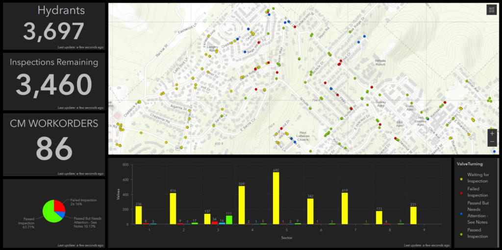
Albuquerque Bernalillo County Water Utility Authority
Problem: Albuquerque Bernalillo County Water Utility Authority needed a more streamlined process for annual inspections of the city’s thousands of fire hydrants. The former solution was inflexible and cumbersome to deploy and maintain.
Solution: The ActiveG solution makes it simple to collect inspection data, to monitor progress, and to automate any maintenance that results from the inspection results. ABCWUA’s GIS group publishes a web map on Portal for ArcGIS, making the map available to Albuquerque Fire and Rescue (AFR), via Collector for ArcGIS. AFR uses the map in Collector to locate and record inspections. Those records are synchronized with Maximo using ActiveG Nash Workflows, which automatically stores the inspection results and generates corrective work orders, based on ABCWUA’s business rules (which are defined in Nash).
Benefits:
- High mobile user adoption
- Easy to use
- Low training requirement
- No Maximo knowledge or process awareness required
- Less errors due to elimination of paper processing
- Easier to query inspection-related work orders
- All work orders spatially rendered for assignment
- Work orders now prioritized, based on inspection results
“AFR loves the simplicity of the new mobile inspection web map,
and our maintenance planners love the integration with Maximo.”
— Paul Davidson, IT Manager

Spire Energy
Spire Energy, from St. Louis, Missouri, upgraded to Maximo Spatial Asset Management 7.6, enabling spatial creation of work orders, inspections, and other records.
Problem: While using Maximo Spatial, Spire Energy needed improved functionality for its pipe inspection and maintenance work processes, and better Maximo-to-GIS data synchronization.
Solution: ActiveG created new spatial widgets, and upgraded existing widgets to enhance Maximo Spatial, tailoring critical processes for Spire’s network of pipelines. ActiveG also helped Spire re-design the data synchronization between Maximo and GIS, using the latest sync tools in Maximo and GIS services.
“[ActiveG went] above and beyond to get us what we need and even improved the functionality of the existing widgets.”
— Amy Birrell, Project Lead

Location-based Work Order Assignment
City of Corpus Christi, Texas
Problem: Crew chiefs at the City of Corpus Christi, Texas needed a way to assign work to crews, using location-based means.
Solution: ActiveG MapEngine provides the City of Corpus Christi’s work planners and crew chiefs with a way to use the map to very quickly view large amounts of unassigned work by location, and assign that work to different crews.
“I can now assign work orders very quickly, and group them by location.
What used to take hours, now takes minutes.”
— Bruce Short, Work Coordinator
