Take your Maximo enterprise spatial.
Put our spatial asset management expertise to work.
Synchronization for ArcGIS and Maximo
PowerSync™
Easily create and update Maximo asset and location records using Esri ArcGIS services, and build your foundation for Maximo for spatial visualization.
Spatial Visualization and interaction for Maximo
MapEngine™
Esri Mobile App integration for Maximo
Nash Workflows™
Deploy advanced geo-centric workflows using Esri ArcGIS mobile apps and IBM Maximo in a snap — without coding and without hassle.
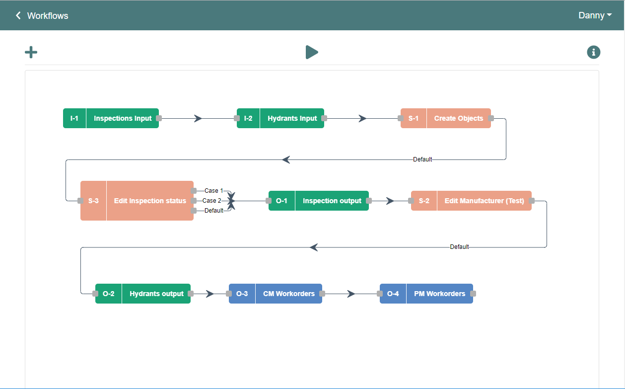
Nash Workflows
Geo-centric workflow engine for ArcGIS, Maximo, and more.
ActiveG Nash Workflows™ is an intuitive, powerful workflow builder for ArcGIS, Maximo, and more.
With Nash you can create rich process integrations, without coding, to maximize the benefits of your enterprise systems like Esri ArcGIS and IBM Maximo Asset Management. The visual workflow editor makes it easy to conceive and deploy rules-based data integrations to harness more from your software investments.
MapEngine
Spatial Visualization for Maximo
ActiveG MapEngine™ seamlessly integrates your Esri ArcGIS and IBM Maximo systems, embedding dynamic maps directly into IBM’s strategic asset management solution.
ActiveG MapEngine brings Maximo and Esri ArcGIS together by map-enabling your Maximo system, and integrating Maximo and ArcGIS at both the data and application levels.


PowerSync
GIS Synchronization for Maximo
ActiveG PowerSync™ is an intuitive, powerful tool for using GIS data to create and update Maximo Assets and Locations, and prepare your Maximo data for spatial visualization in Maximo.
Whether you’re loading data into Maximo for the first time, or you want better data management for Maximo, ActiveG PowerSync efficiently and easily gives Maximo quality data based upon Esri ArcGIS map services.
IBM Maximo Spatial
Implementation and technical services
If your company uses IBM Maximo® Spatial Asset Management, ActiveG can help you upgrade, install, configure, and customize Maximo Spatial to fit your needs.
Our experienced team of GIS and Maximo experts will help you navigate the configuration complexity to help you get the most out of your investment. And we can make Maximo Spatial even more powerful by creating spatial widgets that fit your business processes.
