Locus
Location Tracking for ArcGIS and Maximo
ActiveG Locus is a simple mobile app that publishes user location and other information to a local Esri ArcGIS server. Using Locus puts your crew’s location information on ArcGIS servers you control, rather than in the hands of a third party.
The Locus mobile app works together with a companion Locus server application that is installed on your own web server. The Locus server app provides client authentication using the user’s IBM Maximo credentials. Once logged in, the user’s location is transmitted to the customer’s Esri ArcGIS server.
Once location data is in ArcGIS, this information can be viewed in a variety of work management reports. IBM Maximo users using ActiveG MapEngine can access this information to locate the user’s last position and view historical locations, alongside Maximo work order information.
ActiveG Locus Key Features:
- Publishes user location (last know location and history)
- Publishes info from a connected Bluetooth device, such as an OBD device or other Bluetooth-enabled sensor, allowing you to capture more detailed equipment information, along with your user’s location.
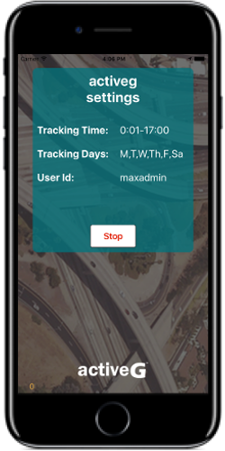
- Administrative control of tracking windows (days and hours).


Location History Reports
MapEngine is a powerful companion to Locus, providing powerful, user-driven, query-based spatial reporting capabilities for Locus.
Choose specific people, Maximo crews or groups to view their location history, juxtaposed with Maximo work orders and assets on the map.