With or without Maximo Linear, MapEngine puts linear in reach.
For departments of transportation, rail companies, pipeline operators, water utilities using Maximo, it’s often necessary to generate a work order that covers portions of assets. However, the work that needs to be done may not fit one-to-one with the segments drawn in GIS. This is where MapEngine helps, no matter if your company is using Maximo Linear or not. In order to make it possible to write a work order to a part or parts of linear assets, MapEngine takes advantage of a concept called dynamic linear segmentation. Dynamic linear segmentation for work orders allows the user to select user-defined segments of rail, highway, or pipes to mark the extent along the asset where work is to be performed.
The Problem: GIS Segmentation vs. Where You Do the Work
Companies that manage linear assets typically have GIS-based digital maps of their infrastructure. Trouble is, inherent issues with the way those maps are drawn prevent them from being used directly to plan or track where the work is actually being done. In the real world, you don’t base your work plans on how the work is drawn and segmented by GIS. You plan or do the work where it really needs to be done.

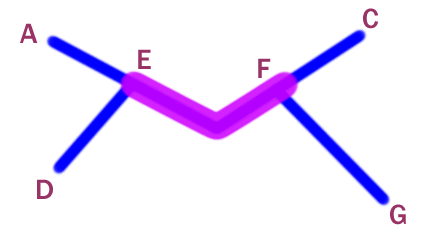
Figure 1: The pink segment represents a single GIS road segment.
The problem lies in the start and end point of the lines on the GIS map. For instance, Figure 1 shows several road segments. One segment is drawn from point E to point F. Using only the data you have from the GIS map, you could click on that segment to indicate that there is some work to be done on that particular asset. But what if you wanted to only do work on a part of that segment? Or what if you wanted to show work that overlapped pieces of two contiguous segments? That’s where dynamic or partial linear segmentation comes in. The technique lets you show your planned and actual work in its true form, whether it’s on a whole or partial segment, or if it spans across several pieces of connected segments.
The Solution: MapEngine

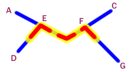
Figure 2: Planned (yellow) and Actual Work (red) Across Multiple Partial Linear Segments
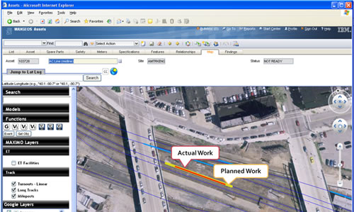
MapEngine enables users to mark and track partial segments of any linear asset visually, whether roadways, rail lines, water/sewer lines, or gas pipelines. Using the previous example, you can use the map to select the portions of the roadway to be maintained and work orders are automatically created in Maximo for any segments that are part of that defined work (See Figure 2).
The Benefits of using MapEngine maps for Linear Asset Management
Maps exposed through MapEngine serve two distinct purposes: 1) they allow visual representation of the assets and the corresponding planned or actual work, and 2) they allow for visual selection to create or define where the work is planned or performed along a linear asset.
While it’s good/required to have a linear asset’s start and ending measures stored in Maximo, it’s better/even more useful to visually interact and manipulate the placement of work on those linear assets.
Frequently Asked Linear Questions:
- What version of Maximo do I need to do linear?
MapEngine enables you to manage linear assets in Maximo 5.x, 6.x, and 7.x. - If I don’t have Maximo Linear, can I do linear with MapEngine?
Yes. Maximo Linear is not necessary to enjoy the benefits of linear in Maximo 5.x, 6.x, and 7.x. - Why would I buy Maximo Linear if I can perform linear asset management just using the MapEngine?
Maximo Linear is only available starting with Maximo 7. The linear capabilities of MapEngine allow you to do linear asset management with your current Maximo release without the need to upgrade to 7. If you have 7 or are upgrading to 7, you have the choice of using MapEngine without the expense of also buying Maximo Linear. The linear measurement fields can easily be configured in MapEngine to point to the Maximo Linear fields. Using the Maximo Linear fields, along with the Maximo Linear business objects, allows you to stay upwardly compatible with any future Maximo Linear capabilities. - If my company already has Maximo Linear, what additional benefit do I get from MapEngine’s linear capability?
Flexible Visualization. While Maximo Linear allows you to store the beginning and ending measures of linear assets, MapEngine uses the linear fields Maximo adds to assets, work orders, etc. and gives you extremely flexible visualization of this information. It’s the visual representation and visual selection of partial linear information that makes managing planned and actual work so much more user-friendly and efficient. And this capability will stay 100% compatible with Maximo for future Maximo Linear functionality. So whether you have Maximo Linear or not, you get a compatible asset visualization solution that is unmatched in flexibility and functionality.
*Partial linear tends to be displayed as thickened or “fat” lines. And with linear it’s always about being “phat”.

Recent Comments